 |
 |


Copyright © 2000,2001
Helmut Gimmler |
|
|
New Links since 2001-Jan-13: |
Rhein-Mesh (River Rhine)
FSMesh
Satellite-Photos |
Mesh-Sceneries:
|
|
Europe mesh by
Mario Groezinger |
Mario Groezinger interpolated several European countries
in 100m (300 ft.) grid spacing from 1km-data. The improvement compared to
the standard scenery is enormous.
I don't use flightsimulator any more without his
scenery! |
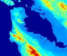
| Rhein
mesh by Burkhard Renk |
Scenery of the Rhein valley between Bingen and Lahnstein, the
famous Loreley rock and surroundings. Includes a 38m elevated mesh scenery
of the valley, a proper readraw of the hydrography and the railway lines
on both sides of the river, with a tunnel through the Lorelay. |
|
|
Tools:
|
|
| Microsoft
Terrain-SDK |
short introduction for mesh terrains incl. tools:
1. Resample - reads 16-Bit-Integer grid elevation data, parameter
via control-file *.INF
2. Compress - use when required
3. Tmf2bgl - converts *.TMF-files (created by step 1 or 2)
into *.BGL-files |
| read_dem.exe |
DEM-Reader for USGS-ASCII-DEM- and SDTS-data
creates headerfile with information for *.INF-file
Pennsylvania State University, Earth System Science Center |
| course:
Geograph. Coordinate Systems |
Coordinate Systems by Peter H. Dana |
| Coordinate
Transformation offline |
course for coordinate transformation with formulas and
parameters:
42 pages / 750KB PDF-file:
Ordnance Survey, the national mapping agency of Great
Britain |
| Coordinate
Transformation online |
input form at the homepage of Bernd Scherer |
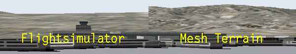
| FSMesh |
FSMesh is a new scenery design tool for MS Flight Simulator 2000.
It is intended to integrate the creation of big, high detail elevated mesh
terrain and base scenery objects. You can import mesh information from DEM30
- files, DHM - 100 files and FSRail files. You can enter additional information
based on background images, scanned or digital maps as examples. You can
modify every input point to correct for errors or to adjust to your sceneries
need. Input to FSMesh has not to be in any grid form. FSMesh is not a freeware
program. |
|
|
Raw Data Elevation Models:
|
|
| DEM Teck in
50m grid |
Landesvermessungsamt Baden-Wuerttemberg / Germany |
| DEM
USA in 30m- and 90m-grid |
1:24,000 DEM (SDTS) and 1:250,000 DEM by U.S. Geological
Survey (USGS) |
| DEM
global in 900m-grid |
GTOPO30 by U.S. Geological Survey (USGS) |
|
|
Raw Data Aerial Photos:
|
|
| Technical
Search |
NASA: Earth from Space - Technical Search |
| Clickable
Map |
NASA: Search All Astronaut Photography of Earth - Clickable
Map |