Copyright © 2001
Helmut Gimmler
Introduction for Mesh-Users
What is Mesh-Terrain?
To display the shape of the landscape in FS2K the whole earth is covered with an 'elevation-mesh'. The elevation-mesh is a geographical grid system which represents the elevation of the terrain. It shows where a hill or valley is situated and how they are shaped.
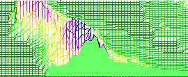
As an example you can imagine a model railway with mountains made out of plaster: First you take a wire mesh and fix the grid points at the correct altitudes. Then you cover the wire mesh with plaster. The wire mesh represents now the elevation model of the terrain in the flightsimulator, the plaster represents the interpolation-algorithm: All points inside the grid are interpolated with a smooth surface.
Textures are independent from the mesh-terrain!
Mesh terrain is an exact 'plaster model' of the earth, but still it is 'white' or 'colourless'. If you think again of your model railway now sprinkle the coloured sawdust: a blue river, dark green wood, light green grass etc. That's what the flightsimulator does: It covers the 'white' landscape with the standard in-built textures like wood, rivers, villages etc.
Summary:
Mesh-terrain determines the shape of the terrain (mountainous, flat,
peak, valley) and
textures are responsible for the 'colours' (wood, meadow, desert, river,
town)
Why should I use mesh-terrain?
 The normal grid spacing (distance of the sample points)
for the elevation points in FS2K is about 1km (0.7miles). That means the
whole earth is covered with a realistic elevation grid of 1sqkm
meshs.
The normal grid spacing (distance of the sample points)
for the elevation points in FS2K is about 1km (0.7miles). That means the
whole earth is covered with a realistic elevation grid of 1sqkm
meshs.
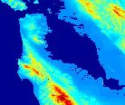
The 3D image shows the southern half of the bay area of San Francisco in
the normal flightsimulator resolution.
 Fortunately the FS2K allows any grid spacing: Interesting areas
are available as 'mesh terrain' in 1500ft down to 150ft resolution. It's
especially helpful for rivers or mountainous terrain. With the 500ft-resolution
the hills and slopes have a realistic effect without a lot of influence on
the frame rates.
Fortunately the FS2K allows any grid spacing: Interesting areas
are available as 'mesh terrain' in 1500ft down to 150ft resolution. It's
especially helpful for rivers or mountainous terrain. With the 500ft-resolution
the hills and slopes have a realistic effect without a lot of influence on
the frame rates.
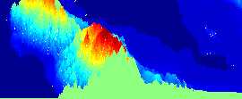
For comparison the 3D image shows the same area in about 600ft resolution.
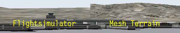
The effect in the flightsimulator can be seen at the screenshots at the top
on this page:
On the left you can see the San Francisco airport in normal resolution, on
the right the more precise 'mesh-resolution' is used.
How mesh-terrain is added to the scenery library?
Like any other scenery, though the 'layer' should be greater than '1' (this seems to be the standard FS2K mesh) and less than the layer number of the scenery which shows the airports, houses etc. for the desired area.